Lower Wairarapa Valley Development Scheme Stage One Engagement
Share Lower Wairarapa Valley Development Scheme Stage One Engagement on FacebookShare Lower Wairarapa Valley Development Scheme Stage One Engagement on X (formerly Twitter)Share Lower Wairarapa Valley Development Scheme Stage One Engagement on LinkedinEmail Lower Wairarapa Valley Development Scheme Stage One Engagement link
Help shape the future of the Lower Wairarapa Valley Development Scheme
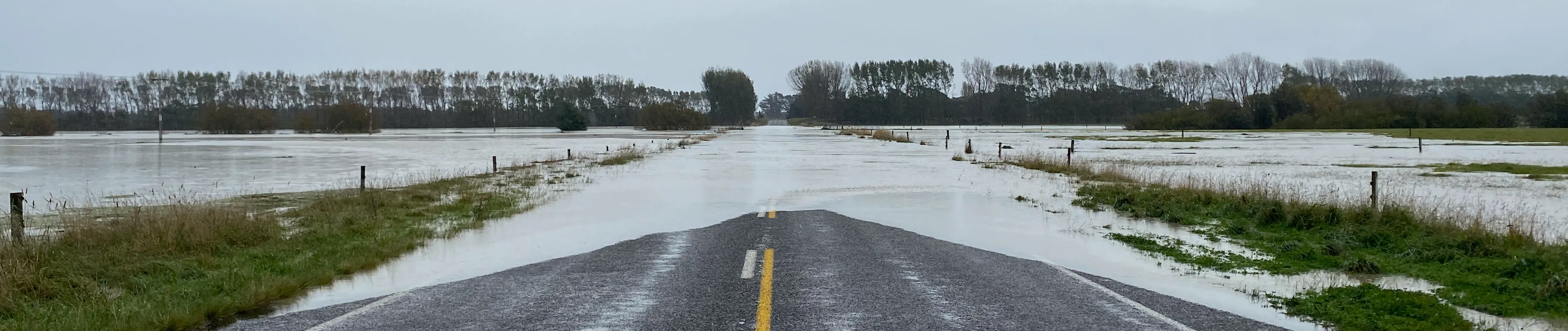
Greater Wellington is starting a review of the Lower Wairarapa Valley Development Scheme. With recent flooding across parts of South Wairarapa affecting farmland, roads and bridges, we know flooding is front of mind for many people. We’d like to hear from people who live, work, own land or have a connection to the Lower Wairarapa Valley.
This first stage of engagement is about building a clearer picture of the area today. We’re asking the community to share local knowledge about past flooding, environmental changes and what people value aboutContinue reading
Help shape the future of the Lower Wairarapa Valley Development Scheme
Greater Wellington is starting a review of the Lower Wairarapa Valley Development Scheme. With recent flooding across parts of South Wairarapa affecting farmland, roads and bridges, we know flooding is front of mind for many people. We’d like to hear from people who live, work, own land or have a connection to the Lower Wairarapa Valley.
This first stage of engagement is about building a clearer picture of the area today. We’re asking the community to share local knowledge about past flooding, environmental changes and what people value about the area.
Your information will help support flood hazard modelling and the wider review of the scheme. This first stage is focused on listening and gathering information, with any future decision-making informed by what we learn.No decisionsregardingthe scheme are being made at this stage.
Background
The Lower Wairarapa Valley Development Scheme was built in the 1960s as a drainage scheme for the Lower Valley. It includes stopbanks, channels, drainage works and structures that are managed by Greater Wellington on behalf of the wider community.
The scheme was designed for the conditions and knowledge available at the time. Since then, the Lower Valley has changed, and recent extreme weather has shown why it is important to understand how the scheme performs under today’s conditions.
A lot has changed since the scheme was built. The way land is used, the environment around Wairarapa Moana and the lower Ruamāhanga River, community expectations, Treaty settlement context and weather patterns have all changed over time. This is why it is important to understand how flooding affects people, land, infrastructure and the environment.
Why this matters
Flooding affects more people, more often than any other natural hazard in the Greater Wellington region. Understanding local flood risk helps councils, communities and emergency services plan better and reduce impacts on people, property, businesses, infrastructure and the environment.
Greater Wellington is now starting a future-focused review of the scheme. This review will look at how the scheme is performing, what information is needed to support future decisions, and how we can better understand flood risk and environmental change across the Lower Valley.
Technical modelling is important, but it works best when it is informed by local knowledge. Photos, stories and observations from people who know the area can help us understand where water has gone in past floods, how conditions have changed over time, and what matters most to the community.
Your information will help support flood hazard modelling and the wider review of the scheme. This first stage is focused on listening and gathering information, with any future decision-making informed by what we learn. No decisions regarding the scheme are being made at this stage.
What’s happening now
Stage One engagement is open from Monday 20 July to Sunday 9 August 2026. During this stage we are letting people know the review is starting and asking for information that can help continue to build a shared understanding of the Lower Valley.
We are especially interested in:
photos, videos, stories or observations from past flood events, especially floods in 2000, 2004, 2006 and 2026
where floodwater went, how deep it was, and what areas were affected
changes people have seen in waterways, wetlands, lake edges, drainage, land use or the wider environment
what people value about the area, including cultural, environmental, recreational, economic and community values.
How to have your say
Use the map tool below to share what you know about flooding, environmental change or important places in the Lower Wairarapa Valley.
Explore the map.
Drop a pin or mark an area where you have information to share.
Tell us what you saw, when it happened and why it matters.
Upload photos, videos or documents if you have them.
You can also tell us what values are important to you about the area.
Need more information or to talk to someone?
If you would prefer to share your information another way, or if you need help using the map tool, please contact Greater Wellington and mention the Lower Wairarapa Valley Development Scheme review.
You can email us at floods@gw.govt.nz or post written information to PO Box 11646, Wellington 6142.
Please be aware that any feedback you share on the map tool may be visible to other visitors to this page. Your personal details will be kept private.
Greater Wellington will use the information you provide to help inform flood hazard modelling and the wider review of the Lower Wairarapa Valley Development Scheme. We may contact you if we need to clarify your information or understand it in more detail.
Greater Wellington will collect, store, use and/or share your personal information in an anonymised and aggregated form in accordance with the Greater Wellington privacy statement.
Share your local knowledge now. Click below to use the map tool and share your flood photos, stories, local observations and information about environmental change in the Lower Wairarapa Valley.