FAQ
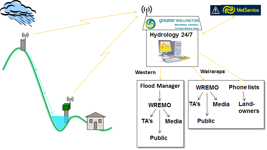
Rain gauges and river level sites are in in place in key locations across the region that record the rainfall intensity and the river levels.
These sites are connected by radio or cellular telemetry to our Hydrotel telemetry systems in Wgtn and Masterton. The data are constantly monitored for rainfall intensities and river levels that exceed preset alarm thresholds.
There are two Duty Flood Warning Officers, who are an experienced member of the Hydrology team, on duty 24 hours a day/7 days a week. One is based from Wellington and the other from Masterton. Their roles and responsibilities are:
The first point of contact for MetService who issue official severe weather warnings. They have a direct line of contact with the MetService Forecast room;
The first person to receive notification of alarms by text and email;
They assess the alarm according to the information available from MetService and then pass on that info to the next person in the chain. This is different between Wgtn and Wairarapa:
In Wellington the duty flood warning officer deals with the Duty Flood Manager who is an engineer from Flood Protection dept. They in turn deal with the WREMO Duty Officer who deals with Local Authorities, Emergency Services, media and the public;
In Masterton the duty Flood Warning officer deals with WREMO and also makes calls to the first contacts on extensive landowner phone tree lists.
- There are also a number of stakeholders that receive automated alarms direct from the Hydrotel Telemetry systems for specific operational purposes.
Why are we doing this review?
Flood warning services in the Wellington Region are provided as a team effort across Greater Wellington Regional Council (GWRC). Flood Warning primarily involves the Flood Protection Department, the Environmental Science Department, and the Wellington Region Emergency Management Office (WREMO) within GWRC. Providing adequate flood warning services is a critical role for GWRC and an area of significant risk if something goes wrong. The current system has not been reviewed recently and has never had a comprehensive review looking at what service is provided and how it is delivered, or indeed why we have a flood warning service at all. The current setup pre-dates the establishment of WREMO in 2012.
How are we undertaking this review?
The Purpose of this review is to make sure our flood warning system is aligned against defined levels of service that have been co-defined with the stakeholders of the service. To do this we are talking to the stakeholders/end users of the service to find out what they expect from a flood warning service. Stakeholders include landowners, emergency services, recreational users, local authorities, roading authorities, MetService, etc.
The Outcomes of this review are a clear definition of the required level of service based on the needs of our stakeholders, and a clear and robust set of improvement recommendations.
How does Flood Warning work now?
There are a number of components that form the existing flood warning system as shown in the diagram below:
What happens next?